


- Education for Homeowners
- Education for Community Officials
Get Educated
Resources and Information for homeowners seeking to increase their knowledge and understanding of flood risk.
- Use the Cost of Flooding tool to measure potential damage.
- Learn more from the Tutorials on how to read Flood Rate Insurance Maps (FIRMs) and Flood Insurance Studies (FIS)
- View the videos from the Georgia Flood MAP YouTube Channel (youTube page link here)
- Browse the collection of Documents for specific questions and guidance
- Search the Glossary for NFIP definitions
The Cost of Flooding
All it takes is a few inches of water to cause major damage to your home and its contents. This interactive tool shows you what a flood to your home could cost, inch by inch.
Measure Your Damage
All it takes is a few inches of water to cause major damage to your home and its contents. This interactive tool shows you what a flood to your home could cost, inch by inch.
Tutorials
Below are available online tutorials to assist in the understanding of floodplain mapping information.
 How to
Read a Flood Insurance Rate Map (FIRM)
How to
Read a Flood Insurance Rate Map (FIRM)
This tutorial educates users on the use and application of FEMA FIRMs.
Each component of the FIRM is explored. The tutorial includes a section
that contains examples of getting specific information from FIRMs.
 How to
Read a Flood Insurance Study (FIS)
How to
Read a Flood Insurance Study (FIS)
This tutorial educates users on the use and application of FEMA FIS texts.
Each component of the FIS, including profiles, cross sections, and notes
is explored and explained.
 Letter
of Map Amendment and Letter of Map Revision based on Fill Tutorials
Letter
of Map Amendment and Letter of Map Revision based on Fill Tutorials
This tutorial series was designed to walk you through the application
and information gathering processes you must follow to request single-lot
LOMAs and LOMR-Fs. The tutorial series also provides you with an online
tool to complete portions of the MT-EZ (used for single lot LOMAs) and
MT-1 ( used for LOMR-Fs) forms.
Get Educated
Resources and Information for homeowners seeking to increase their knowledge and understanding of flood risk.
- 2014 Georgia DNR Flood Response Toolkit
- Georgia DNR Quick Guide
- Check the Training Calendar to view upcoming training opportunities.
- View the videos from theGeorgia Flood MAP YouTube Channel (youTube page link here)
- Browse the collection of Documents for specific questions and guidance
Tutorials
Below are available online tutorials to assist in the understanding of floodplain mapping information.
How to
Read a Flood Insurance Rate Map (FIRM)
This tutorial educates users on the use and application of FEMA FIRMs.
Each component of the FIRM is explored. The tutorial includes a section
that contains examples of getting specific information from FIRMs.
How to
Read a Flood Insurance Study (FIS)
This tutorial educates users on the use and application of FEMA FIS texts.
Each component of the FIS, including profiles, cross sections, and notes
is explored and explained.
Letter
of Map Amendment and Letter of Map Revision based on Fill Tutorials
This tutorial series was designed to walk you through the application
and information gathering processes you must follow to request single-lot
LOMAs and LOMR-Fs. The tutorial series also provides you with an online
tool to complete portions of the MT-EZ (used for single lot LOMAs) and
MT-1 ( used for LOMR-Fs) forms.
In an effort to create more flood resilient communities, the Georgia Flood MAP program is conducting meetings for RiskMAP projects to educate on the use of the Flood Risk Database to identify and prioritize flood mitigation projects. Click the links below to learn more about each topic covered.
 Part I: Introduction and Agenda
This portion of the webinar will introduce the speakers and go through the agenda.
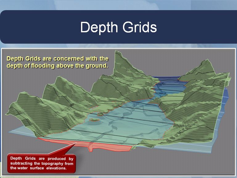 Part II: Depth and Analysis Grids
This portion of the webinar focuses on which depth & anaylsis grids are included in the Flood Risk Database, and how they can be employed to identify potential structural or prevention mitigation activities.
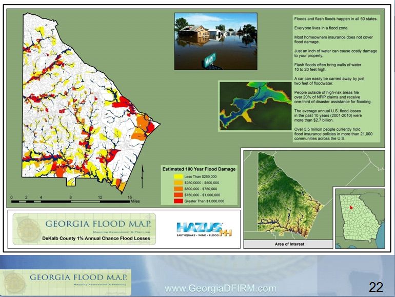 Part III: Risk Assessment Data (HAZUS and CSLF)
This portion of the webinar presents the HAZUS flood loss estimate data provided in the Flood Risk Database, and how to use the Changes Since Last Firm layer to find areas newly mapped into or out of the Special Flood Hazard Area.
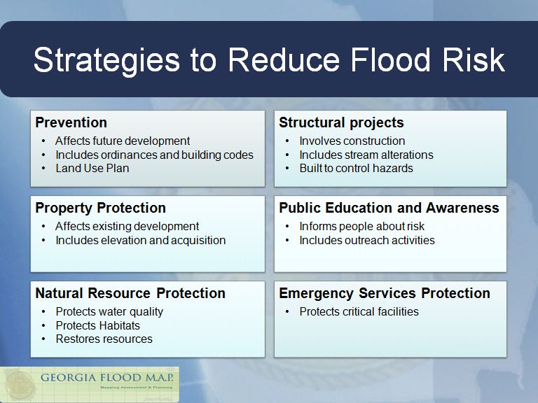 Part IV: Areas of Mitigation Interest & Conclusion
The last part of the webinar lists strategies for identifying and prioritizing flood mitigation projects by type, including strategies for Prevention, Structural, Property Protection, and Education/Awareness projects.